John Speed’s Theatre of the Empire of Great Britaine, housed in the University Library, was the first atlas of the British Isles. It is considered to be one of the world's great cartographic treasures.
Rivers wriggle through the landscape, towns are shown as huddles of miniature buildings, woods and parks marked by tiny trees and – with contour lines yet to be invented – small scatterings of molehills denote higher ground.
Variously described as “charming”, “decorative” and “a supreme achievement in British map-making”, John Speed’s Theatre of the Empire of Great Britaine is more than a map – it is a slice of Tudor and Jacobean life in miniature.
The atlas contains a single sheet for each county of England and Wales, plus a map of Scotland and each of the four Irish provinces, and paints a rich picture of the countryside at the turn of the 17th century.
Rivers wriggle through the landscape, towns are shown as huddles of miniature buildings, woods and parks marked by tiny trees and – with contour lines yet to be invented – small scatterings of molehills denote higher ground.
The countryside bursts with human life: a ploughman and his two-horse team are at work in fields outside Worcester, a group of bathers enjoy the Roman spa at Bath, ducks paddle in the River Ouse at York, and the seas around Britain teem with fabulous sea monsters and ships in full sail.
Inset into the corner of each county map is a plan of its county town and each spare inch of space is used to illustrate famous battles, local coats of arms, as well as Roman and pre-historic sites. All that is missing are the roads because, bar certain bridges and a small stretch of the Romans’ Watling Street in Huntingdon, none are marked.
A rare and delightful item
Anne Taylor, Head of the Map Department at the University Library, often brings out Speed’s Theatre for visitors. But although the department holds several copies of the printed atlas – including a first edition – it is the hand-coloured set of proofs produced between 1603 and 1611 that is one of its greatest treasures.
Bought by the University Library in 1968 after the government refused an export licence for the proofs to be sold abroad, and known as the Gardner copy after its previous owner, Anne describes it as “a rare and delightful item”.
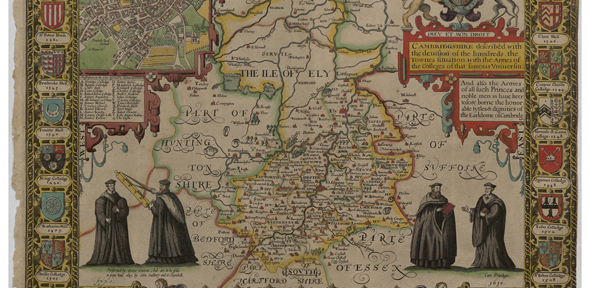
The Cambridgeshire sheet includes portraits of robed academics, a pair of them holding the map’s scale bar, 24 coats of arms of the University, colleges and local nobility, and the inset town plan is bordered by beautiful scroll work.
The Cambridge town plan, wrote the late Nigel Nicolson, author of The Counties of Britain: a Tudor Atlas, “gives a vivid miniature picture of the university and town compressed within an area which in those days extended no further than Castle Hill in the north and Peterhouse in the south”.
Accompanying each map is a description of the county. Derived largely from William Camden’s Britannia, a topographical and historical survey of Great Britain and Ireland, the text offers an affectionate portrait of the city and its university, but a rather less appealing description of the Cambridgeshire countryside.
“This province is not large, nor the air greatly to be liked, having the Fenns so spread upon her North, that they infect the air far into the rest. The soil doth differ both in air and commodities; the Fenny surcharged with waters: the South is Champion, and yieldeth Corn in abundance, with Meadow-pastures upon both sides of the River Came,” he notes.
“From ancient Grantchester, Camboritum by Antonine, now famous Cambridge, the other breast and Nurse-mother of all pious literature, have flowed full streams of the learned sciences into all other parts of this land and elsewhere.”
Speed's cartographic legacy
Enchanting it may be, but how important a map-maker was John Speed and what was his cartographic legacy?
Born in Farndon, Cheshire in 1551 or 1552, John Speed was a historian as well as a cartographer. Nicolson describes him as “an ambitious, energetic man, no great scholar, more a compiler who drew together, both in his histories and his maps, the researches and surveys of others”.
Speed himself paid tribute to earlier map-makers whose work he drew on, especially the county maps of the great Elizabethan surveyor Christopher Saxton. “I have put my sickle into other mens corne,” Speed wrote.
The county maps were the first consistent attempt to show territorial divisions, such as boundaries of hundreds, but it was Speed’s town plans that were a major innovation and probably his greatest contribution to British cartography. Together, they formed the first printed collection of town plans of the British Isles and, for at least 50 of the 73 included in the Theatre, it was the first time these towns had been mapped.
Best described as “map views”, the town plans are a combination of ground-plan with bird’s-eye perspective. “The views set out deliberately to charm,” Nicolson wrote. “They represent towns and cities as havens of peace and industry, neat and speckless.”
Although we know little about Speed’s life, some detective work by Emmanuel College’s Development Director and Fellow Librarian Dr Sarah Bendall – who discovered drafts of Speed’s town plans at Merton College, Oxford – uncovered clues about how he worked during the summers of 1606 to 1608.
According to Dr Bendall: “Initials on four of the sheets suggest that Speed was helped by his son John in 1606. The draft maps also show that his surveying technique was probably a compass traverse using a plane table, and that he worked quickly – he was in Ely on 5 July 1607, Huntingdon on 7 July and Peterborough a day later.”
From 1607 to 1611 the gifted Flemish engraver and map-maker Jodocus Hondius Sr produced the copper plates from which the Theatre was printed, plates that passed between publishers for the next 150 years.
When published – as an accompaniment to Speed's Historie of Great Britaine – in 1611-12 the Theatre was an immediate success: the first print run of around 500 copies must have sold quickly because many editions followed and, by the time of the 1627 edition, the atlas cost 40 shillings.
Both the price and the absence of roads suggest the Theatre would have been bought by local landowners as a status symbol and tool of administrative control. Nicolson imagined too that they might have served the same purpose as today’s coffee table volumes as “a way of travelling in the imagination without expense or fatigue”, and in the 1640s the atlas was used by both armies in the English Civil War.
The Theatre was a supreme achievement in British cartography. It made John Speed into one of the most famous of all our map-makers and became the blueprint for folio atlases until the mid-18th century.
However noblemen used it 400 years ago, today it tells a different story, and one that would surely have pleased Speed. According to Nicolson: “For us it has an additional value that he could hardly have forseen: it is a historical document that clearly presents us with a picture of Elizabethan and Jacobean Britain that could be conveyed in no other way.”